

There are many projects of SmartSolo in engineering geophysical survey among which those using microtremor survey method are also of reference. Our products - SmartSolo, which is the world’s first smart seismic senor, has been successfully applied in many engineering geophysics projects over the past few years. As one of the important application scenarios of our product, the microtremor survey is worth of paying attention to.
So, what is microtremors? And why can it stand out among many exploration methods?
Microtremor is a kind of complex vibration phenomenon in nature, which is composed of body wave and surface wave, and the energy of the surface wave is exceeding more than 70% of total energy。The microtremor survey mainly used the seismometer array to detect the 'noise' from the ground, the most common array shape is circular, triangular, cross, or linear. The dispersion characteristics of the surface wave can be obtained from the acquired microtremor data, and the dispersion curve and H/V curve can be calculated and inverted. As a result, the shear wave velocity model and the predicted lithology of the formation can be obtained. Microtremor survey method is a complex vibration composed of body wave and surface wave, and the energy of surface wave accounts for more than 70% of the total energy. It mainly uses the method of array to receive micro-motion information, and the array mainly adopts circular, triangular, "+" shape and linear arrangement. The dispersion characteristics of Rayleigh surface waves were extracted from the microtremor survey method information, and the shear wave velocity was obtained by inverting the dispersion curve and H/V curve, so as to infer the formation structure in the shallow part of the crust.
At present, SmartSolo have been used to carry out several microtremor surveys in different urban rail-transit construction projects and have received high attention. Compared with other engineering geophysical exploration methods, it has the following four advantages:
- No damage to underground structures and pipelines
- Not limited to the site location, with strong anti-interference ability
- Convenient to conduct survey, high efficiency at low cost
- Environmental friendly
Here's how such projects are implemented in detail:
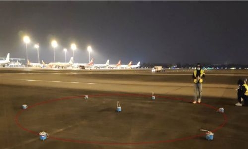
Shield tunneling beneath an airport runway may cause the delamination and voids between the pavement and the tunnel. The MSM could be used to detect where there is a hidden cavity under the runway and its location and size.
Shield tunneling under the airport may cause delamination holes between the airport pavement and the subway tunnel. The main purpose is to investigate whether there is a hidden hole under the airport runway and to determine the specific location and size of the underground hidden hole.
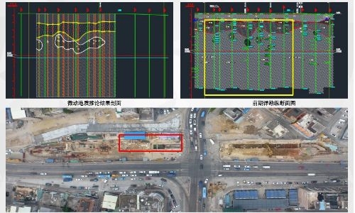
1. Lagging settlement monitoring:
Monitoring the formation stability and local changes after the shield tunnel passes to prevent the formation delinking and cavity formation caused by sand and soil loss.

2. Construction safety risk Investigation:
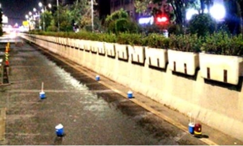
- Dynamic monitoring of subgrade and subsurface stratigraphic changes;
- Investigate the hidden voids below the road surface;
- Detect the delamination caused by sand and stone loss below the road surface;
Shield tunneling through the landmark building, the geological risk of shield tunneling interval is detected and investigated by means of microtremor survey method, no drilling, no dust, no noise, and the construction risk of shield tunneling is effectively eliminated and the construction task is completed with high quality.
3. Poor geological body detection:
Karst feature detection in Shenzhen metro line
The prediction of the karst cave by microtremor survey method is in good agreement with the result of drilling, which makes up the blind area of geological information between the drilling.

The prediction of cavity based on microtremor survey is highly consistent with the geological drilling, which makes up for the lack of geological information between boreholes.

After the shield tunneling machine passes through the karst area, we invert the data from microtremor survey to unveil the geological information, and to locate the karst cave precisely.

Different types of platform arrays are arranged, and the scale prediction is realized on the basis of accurate positioning of the karst cave, which is highly consistent with the later drilling.

Other than the accurate positioning of karst caves, the plane distribution of cavities can be also determined by setting up different shapes of seismometer array.
4. Detection and positioning of municipal pipelines:
- Probe the size and direction of the pipelines;
- Determine the absolute position and relative position of the underground pipelines.

Although the engineering geophysical projects are result-oriented, an efficient, simple, and convenient geophysical exploration method and a piece of efficient and stable equipment are both important and indispensable. We are looking forward to bringing more practical cases and creating greater economic value for the industry.
